Editor’s note: Years before Sandy and its record-level storm surge, scientists warned that the New York metro area faces a rising threat from severe storms, as climate change leads to rising sea levels and shifting weather patterns. In September, of this year, six weeks before Sandy arrived, a New York Times headline summed up the response to date: “New York Is Lagging as Seas and Risks Rise, Critics Warn.”
New York City “is second only to New Orleans in the number of people living less than four feet above high tide,” the Times reported. But despite some positive initiatives, experts interviewed by the Times in September, 2012 said the city’s response lags far behind the scale of what is required.
Below is an excerpt from a 2005 study, “Threats and Responses Associated with Rapid Climate Change in Metropolitan New York,” that is now getting renewed attention. Its authors include Frank Buonaiuto, associate professor of earth and environmental sciences at Hunter College, and other members of the Storm Surge Research Group at SUNY-Stony Brook, led by Malcolm Bowman, professor of oceanography at Stony Brook.
Though this study was written seven years ago, today it reads like a news report. It was originally published as one chapter of Sudden and Disruptive Climate Change, from the Climate Institute. The excerpt below describes the scope of the problem; the rest of the article examines different sea barriers around the world and recommends such an effort in metropolitan New York.
______________________________
Metropolitan New York is vulnerable to coastal flooding and widespread damage to urban infrastructure, commercial structures and residential neighborhoods from both seasonal hurricanes and extra-tropical storms. A significant portion of the metropolitan area lies less than 3 m above mean sea level.
Many types of structures are located within this low-lying region, including commercial properties and financial institutions, apartment buildings and private dwellings, hospitals, police and fire stations, marine transportation terminals, three major airports, heliports, numerous underground railroad and subway lines (with associated station entrances and ventilation shafts), highways, bridge access roads, tunnels, power plants, the underground steam district heating system, electrical and communication networks, landfills, 14 waste water treatment facilities and 770 combined sewer overflows with their tide gate regulators discharging near or at sea level.
Recent storms have already revealed the intrinsic potential for disaster in this region. For example, the nor’easter of December 1992 flooded the entrance of the Hoboken train station with seawater, short-circuiting the electric trains and city subways and shutting down the underground public transportation system for up to ten days. The Brooklyn–Battery tunnel experienced serious flooding, as did the FDR Highway on Manhattan’s East Side. Fortunately, no lives were lost, but there would have been fatalities if the sea had risen another 30 cm (US Army Corps of Engineers et al, 1995). During the 21st century, rising sea level will aggravate the effects of storm surges and wave damage along the metropolitan New York, Long Island and northern New Jersey coastlines, leading to more severe and more frequent flooding. An abrupt acceleration in the pace of climate change would accelerate sea level rise and make infrastructure protection measures and emergency planning imperatives even more urgent.
Hurricanes and Nor’easters
The height and reach of storm surges and flooding along low-lying coastlines are influenced by a variety of factors, including offshore morphology, coastline geometry, astronomical tides and both the regional and local wind and pressure fields. Tropical (for example, hurricanes) and extra-tropical (for example, nor’easters) storm systems are associated with different wind and pressure fields, and these produce characteristically different storm surges. Extra-tropical storms cover a larger geographical extent and often elevate water level across the entire shelf, whereas tropical storms are geographically smaller. However, their strong winds can drive large local surges that propagate with the eye of the storm.
The waterways surrounding New York City are particularly prone to flooding because of the gentle topography, indented coastline and shallow bathymetry of the region (both inside the New York-New Jersey harbor estuary and on the inner continental shelf). The orientation of the axis of Long Island Sound positions it as a natural funnel for strong northeasterly winds driving storm surges down to the western Sound, through the East River and into New York harbor. Northeasterly winds blowing parallel to the southern coast of Long Island also drive surges against the south shore of Long Island that then penetrate into the harbor’s Upper Bay through the Verrazano Narrows, the main entrance to the Port of New York. This is explained by the Ekman effect due to the rotation of the Earth, where in the northern hemisphere, surface waters veer to the right of the wind direction.
 |
The onset and duration of storm surges differ significantly between hurricanes and winter nor’easters…. [T]he oscillating surge from a hurricane typically lasts only a few hours, but rises and falls very rapidly. The extent of flooding, therefore, depends critically upon the state of the astronomical tide at the time of landfall. For nor’easters, by contrast, the surge typically rises more slowly but lasts a few days…running the risk of flooding with each high.
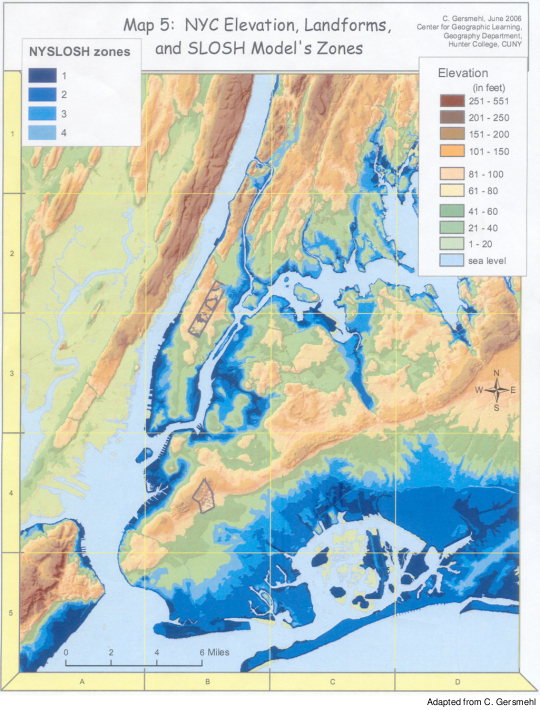
Previous investigations have shown the flooding susceptibility of metropolitan New York associated with hurricanes of varying intensity. [On this page] is a digital terrain map of metropolitan New York with estimates of inundation zones…caused by a direct hit by hurricanes of categories 1 to 4…. [These] predictions are necessarily approximate (accurate to within ± 20 percent) and are highly dependent on how the computational grid is set up. However, the possibility of a major flooding catastrophe is obvious even for a category 2 hurricane.
Vulnerable
Significant sections of the lower west and east sides of Manhattan Island, Queens and Brooklyn boroughs, and the east coast of Staten Island are vulnerable. Jamaica Bay and environs…are clearly at risk, as is JFK Air on the eastern shores of the Bay. Twenty-five subway stations in Brooklyn alone have entrances at or below 10 m above mean sea level…. [P]redictions for northern New Jersey [indicate that flooding] would be considerable, including the Hackensack Meadows, Port Elizabeth and Newark Airport…, as well as the ocean coast of New Jersey…. [A]ll of the south shore of Long Island, plus the two eastern forks, are at risk of inundation from storm surges. Protecting Long Island poses a second major challenge, but beyond the scope of this contribution. Coastal New Jersey faces a similar predicament.
Sea level as recorded at the NOAA Battery primary tide station at the southern tip of Manhattan Island has risen over the past one and a half centuries at a rate of about 30 cm (1 ft) per century. In the metropolitan region as a whole, sea level increased by 23–38 cm (9–15 inches) during the 20th century. The statistical return periods of storm surge-related flooding events [i.e., the length of time between storms] decrease with sea level rise, independent of any global warming effects on the weather itself, so getting a handle on the future rate of rise is important.
Rising Faster
Note: The current trend is the extrapolated secular rise in sea level as recorded at the Battery tide station over the last 150 years and is not primarily associated with global warming, but with isostatic adjustment of the continent following the last glaciation….Extrapolating the current trend, global sea level would be expected to rise by another 0.3 m (1 ft) by the 2090s. As a result, surge-related floods would be higher, cover a wider area and occur more often. Future storm surges would ride on this elevated base level, so the potential damage inflicted by a future 30-year event would be expected to be equivalent to that of a present-day 100-year storm.
However, the pace of global warming is expected to intensify unless very sharp limitations in emissions occur…and the vulnerability and threats of inundation of the New York metropolitan region will correspondingly increase. Projections based on climate change simulations made in 2001 suggest that, excluding the contributions from dynamical ice flow of the Greenland and the West Antarctic ice sheets, sea level will rise by 10–30 cm (4–12 inches) in the next 20 years, 18–60 cm (7–24 inches) by the 2050s, and 25–110 cm (10–42 inches) by the 2080s.
More recent projections for these terms (i.e., other than from significant deterioration of the polar ice sheets) are slightly lower than those estimated in the Third Assessment Report of the IPCC…. However, there are signs that the Greenland and West Antarctic ice sheets are starting to lose mass, so higher levels of sea level rise continue to be plausible. For the highest estimate of sea level rise by the 2090s, which is roughly 1.6 m (3.8 ft), the return period of a 100-year equivalent-damage storm may drop to every other year.
Short-term fixes have already been undertaken, such as fitting moveable gates at the entrances to the PATH train station in Hoboken (which was inundated with seawater during the 1992 nor’easter). However, to protect the myriad individual structures with seawalls or, where feasible, by raising subway entrances and ventilation shafts above grade, would become increasingly difficult and would end up, presumably, with seawalls being constructed along the several hundred miles of shoreline in the metropolitan region…. Planning must take into account the worst case that could ever be contemplated over the life of the barriers (say 200 years); anything less would be inviting disaster….
The surprise is that the feasibility of this concept to protect the NY-NJ metropolitan area has not yet been established. While there would be many engineering challenges to be overcome, there can be little doubt that such structures could be built, the questions are:
- How physically and cost effective would barriers be in protecting the city core?
- Would such barriers amplify surges on the weather ocean) side to an unacceptable degree?
- Would the rivers swollen with rainfall lead to flooding within the barriers anyway?
- Would there be sufficient protection and greater cost-effectiveness with partial blockage at some of the barrier locations?
______________________________
RELATED COVERAGE:
Sandy: Protecting the City from the Sea – Hard and Soft Solutions
Viewpoint: From Disaster to Community Power
CUNY Responds to Sandy: Suffering Spurs Solidarity
Shelter from the Storm at CUNY
PSC Member Works to Save His Home
CUNY’s Temporary Bank for Annual Leave
Help for PSC Members
Stop Mold Before It Takes Hold